


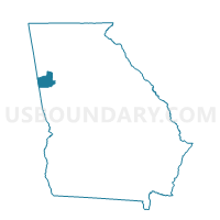
045714BN - EMC Voting District, Carroll County, Georgia
About
Outline

Summary
| Unique Area Identifier | 560478 |
| Name | 045714BN - EMC Voting District |
| County | Carroll County |
| State | Georgia |
| Area (square miles) | 5.64 |
| Land Area (square miles) | 5.64 |
| Water Area (square miles) | 0.00 |
| % of Land Area | 100.00 |
| % of Water Area | 0.00 |
| Latitude of the Internal Point | 33.62561530 |
| Longtitude of the Internal Point | -85.07940850 |
Maps


Graphs
Select a template below for downloading or customizing gragh for 045714BN - EMC Voting District, Carroll County, Georgia


Neighbors
Neighoring Voting District (by Name) Neighboring Voting District on the Map
- 0451122 - SANDHILL Voting District, Carroll County, GA
- 0451152 - CENTER POINT Voting District, Carroll County, GA
- 0451496 - BOWDON JUNCTION Voting District, Carroll County, GA
- 045501 - BETHANY Voting District, Carroll County, GA
- 045714A1 - WEST CARROLLTON Voting District, Carroll County, GA
- 045714A2 - EAST CARROLLTON Voting District, Carroll County, GA
Top 10 Neighboring County Subdivision (by Population) Neighboring County Subdivision on the Map
Top 10 Neighboring Place (by Population) Neighboring Place on the Map
Top 10 Neighboring Unified School District (by Population) Neighboring Unified School District on the Map
Top 10 Neighboring State Legislative District Lower Chamber (by Population) Neighboring State Legislative District Lower Chamber on the Map
Top 10 Neighboring State Legislative District Upper Chamber (by Population) Neighboring State Legislative District Upper Chamber on the Map
Top 10 Neighboring 111th Congressional District (by Population) Neighboring 111th Congressional District on the Map
Top 10 Neighboring Census Tract (by Population) Neighboring Census Tract on the Map
- Census Tract 9105.01, Carroll County, GA (8,876)
- Census Tract 9103, Carroll County, GA (6,310)
- Census Tract 9106, Carroll County, GA (5,568)